
3D Printing Topographic Maps: How to Print Landscapes

Topographical and relief map data are useful for 3D printing topographic maps. Learn all you need to know to print your own!
There’s something endlessly fascinating about three dimensional topographic maps. Traditionally made from carved wood, bronze castings, or even vacuum formed plastic, 3D printing has brought a new lease of life to these sculptural representations of the lands we live on.
Think of a traditional map of the Grand Canyon – a few closely packed contour lines are the only clue to the stunning depths of the landscape. But viewed as a 3D topographic map, it comes to life and gives an instant impression of the canyon walls and the twists and turns in the floor below.
Also known as physical terrain maps, raised relief maps, or elevation maps, 3D topographic maps help viewers “tune in” and find points of reference more easily than flat representations. For this reason, they’re often used in visitor centers and museums. They’re also pleasing to the eye and frequently sold and used as art, for decorative purposes, or as a memento of locations that hold special memories.
Although 3D topographic maps can look complex, the data to make them is readily available for most of the world and there are several ways you can personalize and create your own 3D printed versions.
And if you find the map of your dreams but don’t have a 3D printer at hand, don’t worry. With Craftcloud, your topographic interests can take a new form!
How Are They Made?
Most countries have detailed map and elevation data gathered by traditional map-making techniques and now augmented with the incredible detail of lidar scans. Resolution varies and is often, confusingly to the layman, expressed in arcseconds. One arcsecond is equivalent to about 30 meters.
This data is made available through government websites (e.g. the USGS in the US) and sources such as OpenTopography and OpenStreeMaps. Such data tends not to be readily accessible for download through services such as Google Earth, although it’s possible with the right software.
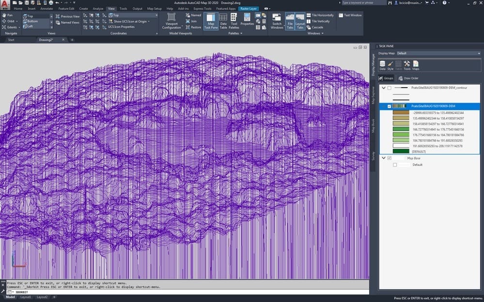
Elevation data is stored in various formats, generically known as digital elevation models (DEM). Dedicated software, such as a geographic information systems (GIS), can read this and convert it into other formats, including 3D printable STL files. Normally the elevation is exaggerated slightly relative to the horizontal dimensions to make features a little more prominent, or sea levels are artificially lowered to make coastlines more obvious.
Although the obscure terminology can be discouraging at first, there’s plenty of online help to describe data, software, and the various conversion processes. Better still, there are several ways that simplify the steps to 3D print a topographic map.
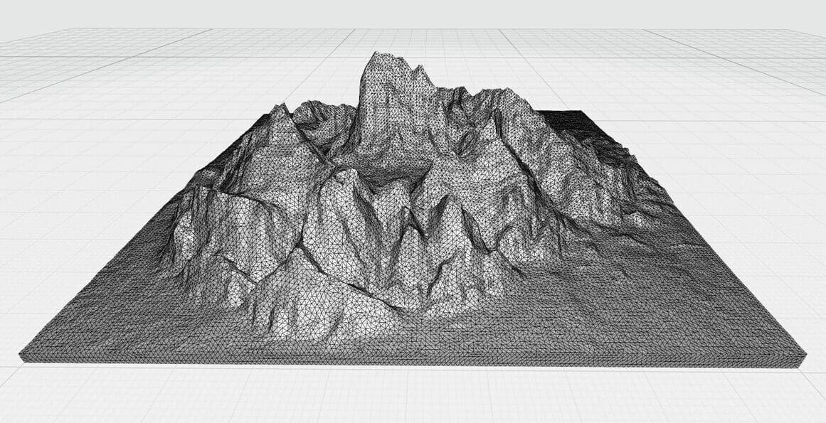
Find a Topographic Map STL
Unless you have a very specific area in mind for your 3D topographic map, the chances are that someone has already “been there, done that”, and shared the STL file.
A look through any of the usual STL or model sharing sites reveals a wide range of impressive models. Remember to search using the alternative names mentioned above too, as a search engine might not know that a relief, elevation, and topographic map are the same in this context!
There are stunning STL files for the entire planet, whole countries (the Netherlands looks especially cool), American parks such as Yosemite, and even a 3D topographic sliding puzzle of Banff in Canada! It’s also interesting to see the various ways these have been made, with a range of painting and post-processing techniques to make the end product look especially cool.
Generate Your Own Map
If no ready-made STL is available, the next easiest option is to use one of several dedicated online services. Three in particular are popular and simple to use.
Terrain2STL
This tool is simple to use and constantly produces good results. Select an area on the online map, adjust a few parameters (for scaling, orientation, height exaggeration, sea-level drop, etc.) and a customized STL file is generated for free. For the majority of cases this tool is all that’s required, however it uses a relatively old data set (from NASA in 2000) with a resolution of around 90 m. For small areas this might not be high enough and one of the next two options may be better.
Touch Terrain
This site, by Iowa State University, supports US geographies only and continues to be updated to use more accurate underlying data – currently down to 10 m for most of the country. Unsurprisingly, its user interface is a little more “academic” and even has a feature to flag cases where the available data is at a lower resolution that what the specified 3D printer can handle. STL downloads are free.
The Terrainator
This option offers access to up-to-date, high-resolution data. The user interface is slick and fast, although there’s a charge for downloading the processed STL files.
More Ideas
If none of the previous options are suitable or you’re keen to understand in more detail how the process works, there are several options to create your own map. Online tutorials on this topic often seem daunting and many are also out of date or misleading, so let’s break down what you need to know and flag useful sources.
Acquire & Process Elevation Data
Sources of elevation data will vary from country to country and are normally found in the public domain from government sources (e.g. the USGS in the US). Alternatively, OpenTopography is establishing itself as a key source of data from across the world, although it’s mainly US-centric and very light on information for Europe. Their tutorials are easy to follow and a great introduction to elevation data. Another free source is OpenDEM.info, which is better for Europe.
Data Format
There is a multitude of data formats to download. They basically fall into three groups: raster data (usually viewable as an image with the elevations shown as shades of grey of different colors), grid data (a numeric tally of X, Y, and Z coordinates in a spreadsheet), and shapefiles (where the elevations contours are described as vector shapes). Converting between these is relatively easy – although may require a little background research – and can be handled by packages such as ArcGIS or QGIS (which you’ll probably need for the next step in any case). Another issue is that the data files may not exactly represent the area you want, but this can be edited and fixed using GIS tools.
Convert Data into a Printable 3D Model or STL
It’s a little-known feature of Cura Slicer that it can read image files and convert them to height referenced 3D prints. If you have a raster elevation image of the area you’re interested in, this might be all you need to generate a great 3D topographic map.
More typically, the conversion is done using plug-in functionality for GIS or CAD tools. There are several excellent tutorials available online, each with a slightly different approach. One good example is the Make 3D Printed Topo Maps Instructable, which contains a great introduction to file types and conversions.
Consensus now leans towards using QGIS, the free GIS tool, with one of a couple of plug-ins: DEMto3D or Qgis2threejs. Both of these have a range of features – not just to convert to an STL but to convert to a range of 3D representations, including full-color options. Again, there are many online tutorials for both of these. A good starting point may be OpenTopography’s tutorial that uses DEMto3D to prepare a DEM file for 3D printing, and which also touches on other manipulation of map and elevation data. Another helpful initial step may be GeoDelta Labs’ guide for using Qgis2threejs to create a generic and detailed 3D model, which can be exported as an STL.
For those with a mathematical inclination, there are plug-ins available for Wolfram and Matlab to convert elevation data files into STL files, too. These may need some post-processing in CAD or modeling software but are a great option for those familiar with these math packages.
Advanced Options

Advanced options might include readying your model for printing by a 3D printing service in full color. The Instructable 3D Print Your Trek, in Color! is long and involved (and some of the earlier parts are slightly out of date), but the last few sections are a great description of how to prepare a model with real-world texturing and imagery.
Alternatively, you may like to superimpose the route of a trek or ultra-marathon on your 3D printed map. This can look incredible and may act as a tangible reminder of expeditions or races.
Why Stick to Planet Earth?
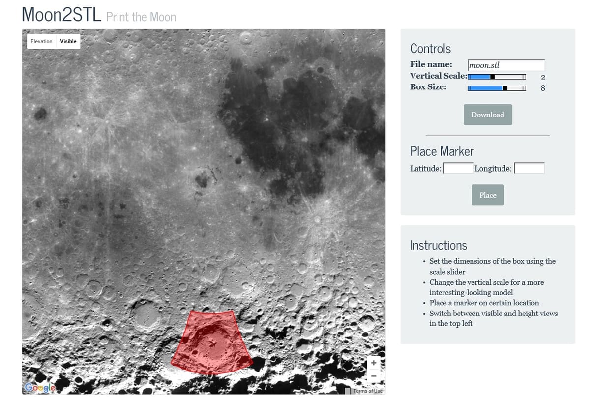
So far, we’ve used examples from our own blue planet. However, elevation data is also freely available for other extraterrestrial bodies including the Moon, the planets Mars, Venus, and Mercury, and other planetary moons such as Europa, Ganymede, and more.
All the options explored above still apply for 3D printing topographic designs. For example, we’ve found impressive 3D topographic maps and models of all of Jupiter’s main moons, such as Io, on Thingiverse.
There’s also an excellent version of Terrain2STL called Moon2STL, and for more detail, The Terrainator has Moon and Mars data with a few pre-selected maps including the Apollo 11 landing site.
If you want to take a DIY approach, raw NASA data can be found on the USGS’s Geologic web pages.

Printing Tips
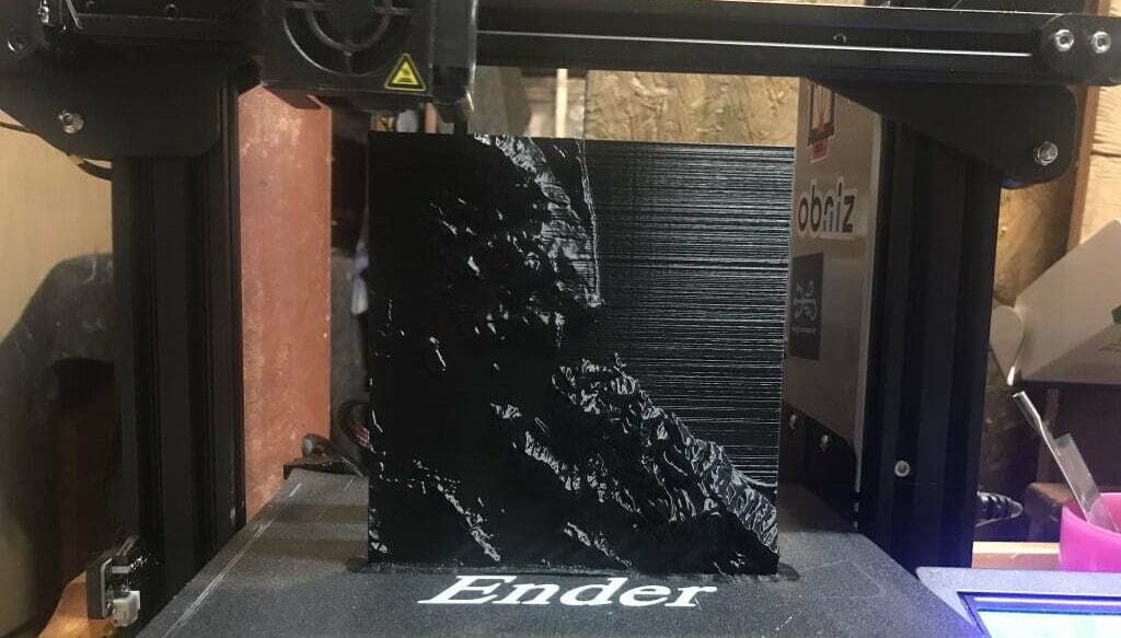
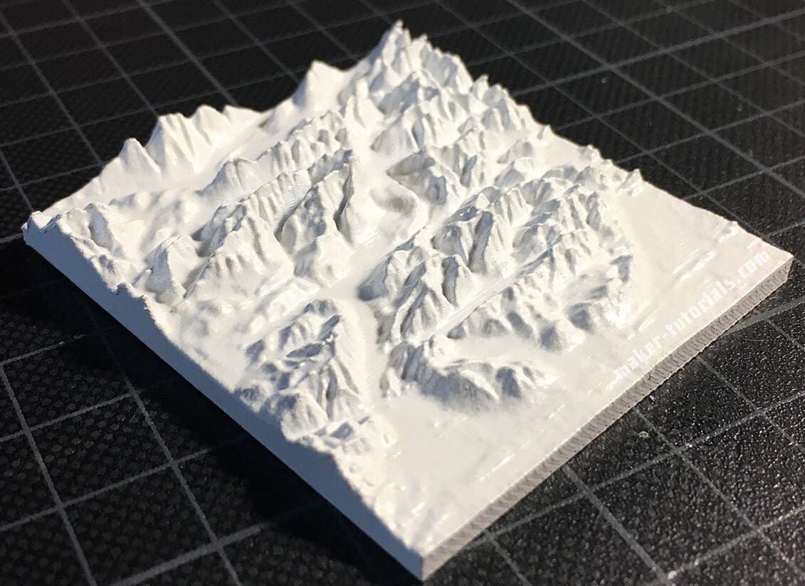
The normal, and most obvious, way to print your 3D topographic STL is horizontally. Depending on the size of the model, it’s usually best to choose a layer height smaller than 0.2 mm so that the lines are less obvious.
In general, a slight sheen helps emphasize the details, which can be achieved by printing at a slightly higher temperature than normal (for PLA) or using a silk PLA filament.
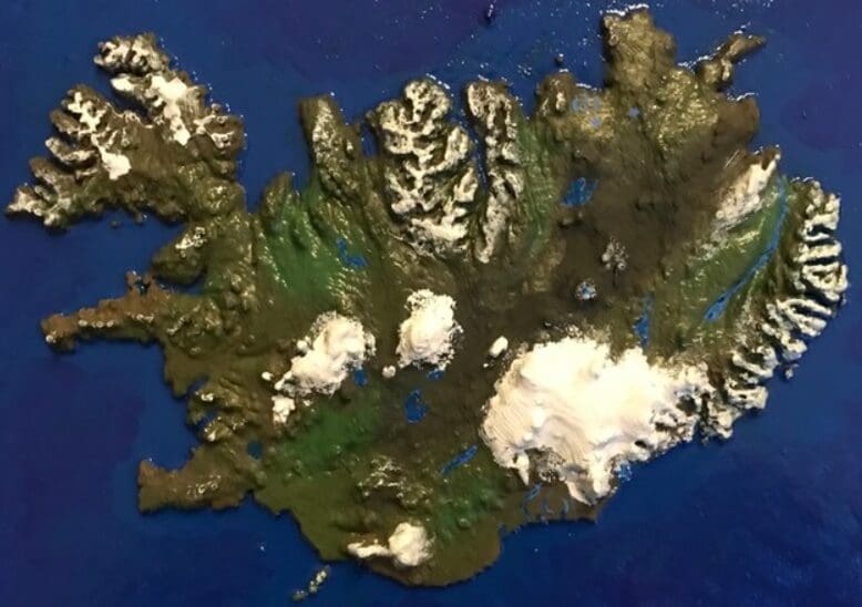
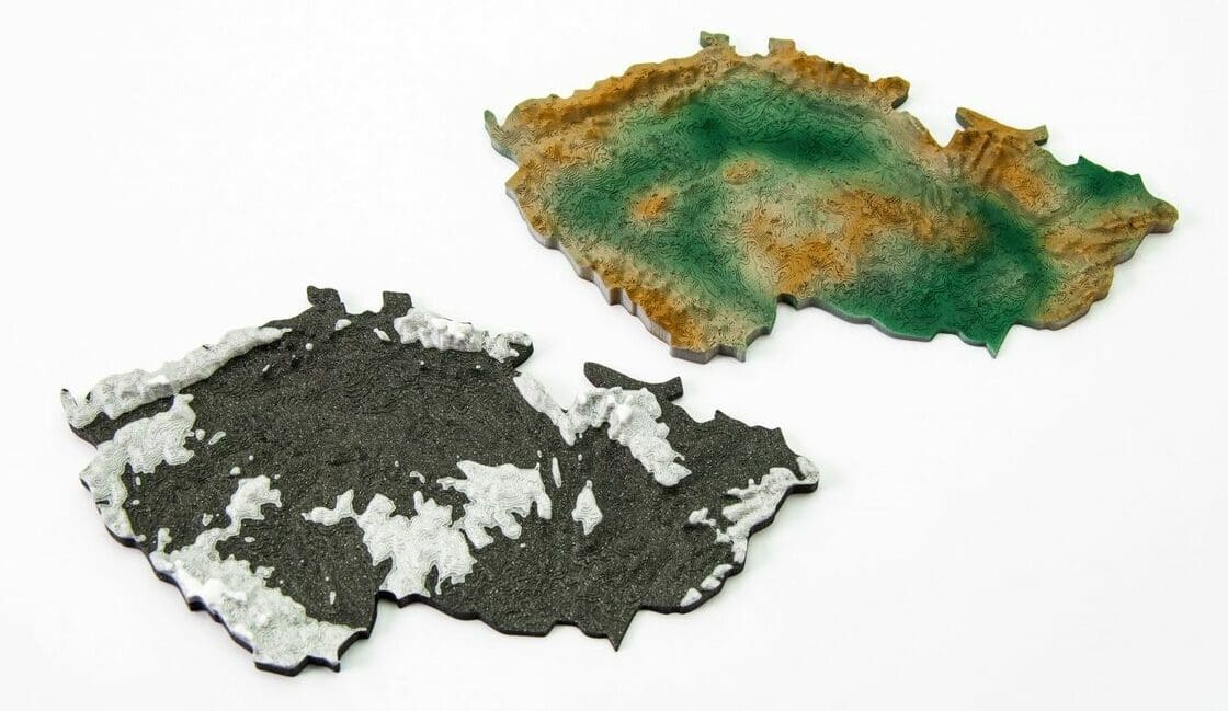
Changing filament during printing, to emphasize differences in layer height, can also look fantastic. For example, blue for the sea, green for the land, and white for high mountain peaks. Alternatively, using post-processing techniques to replicate cast bronze or carved wood can be very effective, as can painting in a photo-realistic “satellite view” manner.
Another popular printing choice is to orient the map vertically. For smaller prints this can help preserve height details better and also resolves the surface of sea or lakes more consistently. Another big plus of vertical printing is that vase or spiralize mode can be used. This can give another boost to print quality and can significantly reduce printing time. Bed adhesion, of course, can be an issue, so maps with a good wide base work best and remember to print slowly!
License: The text of "3D Printing Topographic Maps: How to Print Landscapes" by All3DP is licensed under a Creative Commons Attribution 4.0 International License.